
Attention : l’accès des véhicules se situe au 11 avenue Marcelin Berthelot (prendre la rue à droite en arrivant place Janssen et tourner à gauche dans l’avenue Marcelin Berthelot).
Le site de Meudon de l’Observatoire de Paris est le point culminant de la commune.
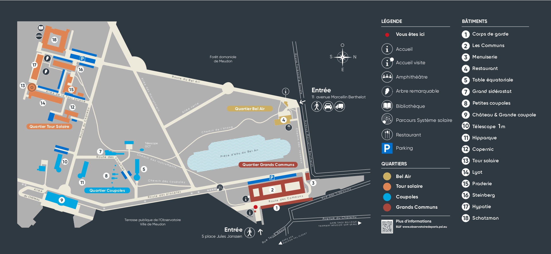
Plan du campus de Meudon
Accès par la ligne N du Transilien (départ à la gare Montparnasse)
Arrêt Meudon-Bellevue, 4 options :
- Bus TIM : A la sortie de la gare, prendre à droite ; la station se trouve sur le trottoir opposé de la rue Louis Blanc. Descendre à l’arrêt Observatoire. Attention, 1 bus par heure. Fiche horaire : en 2023, passages à 7h, 8h, 9h, 10h, 11h, 12, 13h, 14h, 15h, 16h, 17h, 18h, 19h
- Bus 169 direction Paris : A la sortie de la gare, prendre à gauche et traverser l’avenue du château ; la station se trouve sur la gauche. Descendre à l’arrêt Rabelais, puis voir § « Accès à pied depuis les stations de bus ».
- Bus 389 direction Georges Pompidou (Clamart) : La station se trouve à la sortie de la gare, sur la droite. Descendre à l’arrêt Rabelais, puis voir § « Accès à pied depuis les stations de bus ».
- A pied : à gauche en sortant de la gare prendre l’avenue du Château jusqu’à la place Jules Janssen. La montée dure 20-25 minutes à pied (pente douce).
Arrêt Meudon :
- A pied : A gauche en sortant de la gare puis tout de suite à droite, prendre la rue Claude Dalsème sur environ 200 m, puis à droite l’avenue Le Corbeiller. Poursuivre tout droit jusqu’à la place Jules Janssen. La montée dure 15-20 minutes à pied (pente modérée).
Accès par le RER C
- Arrêt Meudon-Val Fleury (trains Versailles Rive Gauche – Paris), puis 3 options :
Bus TIM : traverser la rue de Banes ; la station se trouve très vite sur la droite. Descendre à l’arrêt Observatoire. Attention, 1 bus par heure. Fiche horaire : en 2023, passages à 7h20, 8h20, 9h20, 10h20, 11h18, 12h15, 13h16, 14h17, 15h19, 16h20, 17h20, 18h20, 19h20 - Bus 289 direction Georges Pompidou (Clamart) : traverser le pont de Banes vers la gauche, puis traverser l’avenue Jean Jaurès ; la station se trouve juste à droite. Descendre à l’arrêt Eglise de Meudon, puis voir § « Accès à pied depuis les stations de bus ».
- A pied : traverser le pont de Banes vers la gauche, puis monter la rue de Banes jusqu’au bout. Prendre à gauche la rue de Paris, puis à droite la rue Terre Neuve, jusqu’à la Place Jules Janssen. La montée dure 15 - 20 minutes à pied (pente importante).
Accès en Métro + bus
- Par la ligne 12, descendre au terminus Mairie d’Issy puis prendre le bus 169 en direction du Pont de Sèvres. Descendre aux arrêts Rabelais ou Église de Meudon, puis voir § « Accès à pied depuis les stations de bus ».
- Par la ligne 9, descendre au terminus Pont de sèvre puis prendre le bus 169 direction Hôpital européen George Pompidou. Descendre aux arrêts Rabelais ou Église de Meudon, puis voir § « Accès à pied depuis les stations de bus ».
Accès à pied depuis les stations de bus
- Arrêt Observatoire de Paris (TIM) : vous arrivez directement sur la Place Jules Janssen.
- Arrêt Eglise de Meudon (bus 169 ou 289) : Monter la rue de l’Eglise, tourner à droite sur la D406, puis à gauche sur la rue Terre Neuve. Poursuivre jusqu’à la Place Jules Janssen. La montée dure environ 5 min à pied (pente importante).
- Arrêt Place Rabelais (bus 169 ou 389) : rejoindre l’avenue Jacqueminot, puis la monter jusqu’à la Place Jules Janssen. La montée dure 5-10 min à pied (pente modérée).
Accès en voiture
- Depuis l’aéroport d’Orly (document pdf d’après www.viamichelin.fr).
- En venant de Paris :
- par le périphérique, sortir à Quai d’Issy, prendre les directions d’Issy les Moulineaux, Sèvres puis de Meudon
- par la route nationale 118, à partir du Pont de Sèvres, prendre la direction de Chartres Orléans, sortir à Meudon Sèvres puis se diriger vers Meudon.
Coordonnées
Longitude : 2 ° 14’ Est - Latitude : 48 ° 48’ Nord - Altitude : 162 mètres